Antique map of South East Asia - Johannes Janssonius by Johannes Janssonius
Scroll to zoom, click for slideshow

Antique map of South East Asia - Johannes Janssonius 1630

Johannes Janssonius

Papel
39 ⨯ 50 cm
€ 1.850

Inter-Antiquariaat Mefferdt & De Jonge

  • Sobre la obra de arte
    A LANDMARK EARLY MAP OF SOUTHEAST ASIA, THE PHILIPPINES, AND AUSTRALIA “Indiae Orientalis Nova Descriptio.“ Copper engraving published by Johannes Janssonius (in English also known as Jan Jansson) in 1630. With original hand colouring. Size (plate mark): 39 x 50,7 cm. This edition of Johannes Janssonius’ map—first appearing in his “Appendix” in 1630—is celebrated for its excellent regional detail and its historical significance. It is notably the only Dutch printed map to record the 1606 discoveries of captain Willem Janszoon aboard the Duyfken, an expedition that led to the first recorded European landing on Australian soil, specifically on the west coast of Cape York Peninsula. In the early 17th century, the Dutch East India Company (VOC) was eager to expand its trade monopoly in the East Indies. In 1605, at the initiative of the VOC, Jan Willemsz Verschoor organized an expedition "to discover the great land of New Guinea and other eastern and southern lands." Willem Janszoon (1570-1636) was selected for this pioneering expedition, setting sail from Bantam (Indonesia) in late 1605. According to John Saris, an agent for the British East India Company, the Duyfken departed on November 28, 1605. In early 1606, after navigating New Guinea’s south coast, Jansz sailed south across Torres Strait—mistaking it for a shallow bay—and continued along what he presumed was the continuation of New Guinea’s coastline. In truth, he was venturing into the waters off the Australian coast. Unbeknownst to him, this voyage marked the first recorded European encounter with Australian soil. In addition, the map also presents the Philippines in detail for the first time. Janssonius drew upon the work of VOC cartographer Hessel Gerritsz, utilizing information that the VOC had strictly controlled in the early 17th century for competitive reasons. Janssonius’ map is significant not only for its depiction of the discoveries in New Guinea, referred to as “Duyfkens Eylant,” but also as the sole printed cartographic record of part of the Duyfken’s route until later maps emerged. While the map uses a scale of miles to cover the area of the Australian discoveries—thus offering less detail on Jansz’s Australian findings—it remains an invaluable document in the history of European exploration in the region. Price: Euro 1.850,- (incl. frame)
  • Sobre el artista

    Janssonius nació en Arnhem como hijo de Jan Jansz, impresor y editor allí. A una edad temprana se mudó a Amsterdam, el entonces centro de la impresión y el comercio de tarjetas. En 1612 se casó con Elisabeth Hondius, hija de Jodocus Hondius. Elisabeth murió en 1627 y Janssonius se volvió a casar en 1629 con Elisabeth Carlier. Se fue a trabajar para su suegro y continuó el negocio editorial junto con Henricus Hondius (hijo de) después de su muerte. Esto se convirtió en uno de los más grandes de su tiempo. Había sucursales en Berlín, Frankfurt, Ginebra, Lyon y Estocolmo, entre otros.

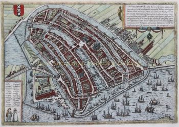
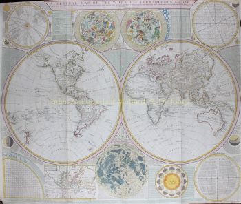
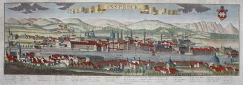
    Bajo el liderazgo de Janssonius, el Mercator-Hondius Atlas se amplió y publicó como Atlas Novus. Esta edición inicial de un volumen pronto se convirtió en un atlas de varios volúmenes, complementado a pedido con cartas náuticas y/o cartas celestes. Hubo publicaciones en holandés, francés, español y latín. Al igual que sus contemporáneos, Janssonius también hizo uso de placas de cobre existentes, incluidas las de los libros de ciudades de Braun & Hogenberg y la Descripción de touts les Pays Bas (Descripción de todos los Países Bajos) de Lodovico Guicciardini - (edición Cornelis Claesz.) de 1609 Aunque a menudo se ha acusado a Janssonius de copiar el trabajo de Willem Blaeu, cabe señalar que los mapas de Janssonius también aparecieron en el mercado antes.

    Después de la muerte de Janssonius, la empresa fue continuada por su yerno, Johannes (Jan) van Waesbergen, quien estaba casado con su hija Elisabeth Janssonius (1615-1681). Frederik de Wit utilizó muchas planchas de cobre de los libros de la ciudad (a veces ligeramente modificadas). El edificio de Dam Square fue alquilado a Gerard Valck; También compró una serie de planchas de impresión en 1694.

¿Está interesado en comprar esta obra de arte?