Achterhoek (condado de Zutphen) 1641
Johannes Janssonius
€ 295
Inter-Antiquariaat Mefferdt & De Jonge
- Sobre la obra de arte
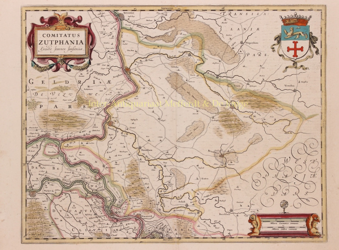
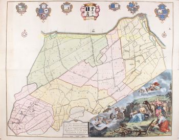
THE QUARTER OF ZUTPHEN "Comitatus Zutphania", copper engraving published by Johannes Janssonius in 1641 as part of his "Nouveau Theatre du Monde ou Nouvel Atlas". Coloured by hand at the time. Measures 46.5 x 56.4 cm. In the years 1557 to 1559 the area was mapped by Christiaan sGrooten. sGrooten's map of Gelderland was also the model for Janssonius' map of the County of Zutphen. We see the Kleef area near Huissen and Zevenaar clearly delimited. Isselburg falls within the border of the County. There are no siege works drawn around Groenlo. The area of the manor of Borculo fell under the Earldom after 1615, but is shown here as part of the Bishopric of Münster. For the city of Zutphen, the Eighty Years' War brought difficult times. In 1572, Zutphen was captured by William of Orange's brother-in-law. The Spaniards were driven out, but half a year later they took the city back and executed hundreds of inhabitants. In 1577, the Spaniards left the city, but the Catholic city council remained in place. In the summer of 1579, the Protestants seized power and deposed the Roman Catholic administrators. In 1583, Zutphen was again in the hands of the Spaniards but after that, the city was besieged two more times by the Staatsen. In 1591, Prince Maurits conquered Zutphen until, in 1629, a German-Spanish army once again invaded the Veluwe and went on a killing spree. Top right, the city arms of Zutphen are depicted, with the Count's Crown on top. Bottom right the scale of the map is flanked by winged angels with claws, on top is an armillary as a symbol of wisdom and knowledge (of the mapmaker). Price: Euro 295,-
- Sobre el artista
Janssonius nació en Arnhem como hijo de Jan Jansz, impresor y editor allí. A una edad temprana se mudó a Amsterdam, el entonces centro de la impresión y el comercio de tarjetas. En 1612 se casó con Elisabeth Hondius, hija de Jodocus Hondius. Elisabeth murió en 1627 y Janssonius se volvió a casar en 1629 con Elisabeth Carlier. Se fue a trabajar para su suegro y continuó el negocio editorial junto con Henricus Hondius (hijo de) después de su muerte. Esto se convirtió en uno de los más grandes de su tiempo. Había sucursales en Berlín, Frankfurt, Ginebra, Lyon y Estocolmo, entre otros.
Bajo el liderazgo de Janssonius, el Mercator-Hondius Atlas se amplió y publicó como Atlas Novus. Esta edición inicial de un volumen pronto se convirtió en un atlas de varios volúmenes, complementado a pedido con cartas náuticas y/o cartas celestes. Hubo publicaciones en holandés, francés, español y latín. Al igual que sus contemporáneos, Janssonius también hizo uso de placas de cobre existentes, incluidas las de los libros de ciudades de Braun & Hogenberg y la Descripción de touts les Pays Bas (Descripción de todos los Países Bajos) de Lodovico Guicciardini - (edición Cornelis Claesz.) de 1609 Aunque a menudo se ha acusado a Janssonius de copiar el trabajo de Willem Blaeu, cabe señalar que los mapas de Janssonius también aparecieron en el mercado antes.
Después de la muerte de Janssonius, la empresa fue continuada por su yerno, Johannes (Jan) van Waesbergen, quien estaba casado con su hija Elisabeth Janssonius (1615-1681). Frederik de Wit utilizó muchas planchas de cobre de los libros de la ciudad (a veces ligeramente modificadas). El edificio de Dam Square fue alquilado a Gerard Valck; También compró una serie de planchas de impresión en 1694.
¿Está interesado en comprar esta obra de arte?
Artwork details
Related artworks
- 1 - 4 / 4
Cornelis Anthonisz Theunissen
MUY RARO PRIMER MAPA IMPRESO DE ÁMSTERDAM, UNA CIUDAD EN ASCENSO1544
€ 175.000Inter-Antiquariaat Mefferdt & De Jonge
 curada por
Danny Bree
1 - 4 / 24- 1 - 4 / 12

