Artois 1656
Nicolaes Visscher
€ 175
Inter-Antiquariaat Mefferdt & De Jonge
- Sobre la obra de arte
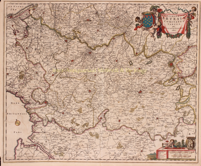
GRAAFSCHAP ARTESIA (ARTOIS) "Geographica Artesiae Comitatus Tabula", copper engraving published in Amsterdam by Nicolaes Visscher I as part of his "Atlas Contractus" between 1656-1677. Verso: blank. Coloured by hand in time. Dim. 46.6 x 56.3 cm. The County of Artesia was one of the Seventeen Provinces in the 16th century. Artesia played an important role at the beginning of the Eighty Years' War. Together with Hainaut, Artesia took the initiative for the Southern Union of Atrecht (Arras). Although the Flemish and Brabant cities sided with the northern Union of Utrecht, the division of the Netherlands had begun, with a northern part striving for independence from the Spanish king and a southern part wishing to remain with the Spanish empire. At the end of the Eighty Years' War, Artesia was conquered from the Spaniards by the French. At the Peace of the Pyrenees in 1659, Artesia was definitively allocated to France. At the top right, putti carry a banderole with the title of the map and the county's coat of arms. A dreamy putto with compass rests on the legend and scale bars bottom right. Price: Euro 175
- Sobre el artista
Nicolaes era el único hijo de Claes Jansz. Pescador. También es conocido por los nombres: Nicolaas o Claes Claesz. Después de años de trabajar para su padre en el negocio, lo sucedió después de su muerte en 1652. En 1662 fue admitido en el gremio de libreros de Amsterdam y en 1677 Nicolaes, ahora un editor respetado, recibió una patente de 15 años de los estados de Holanda y West Friesland para la impresión y publicación de mapas. Murió dos años después y fue enterrado en la misma capilla que su padre.
Las ediciones Atlas de Nicolás I incluyeron:
"Atlas Contractus Orbis Terrarum" de 1657.
Germania Inferior de 1663.
“Atlas Menor” de 1675.
Los atlas de Visscher a menudo se compilaban de acuerdo con los deseos de los compradores (el llamado Atlas Contractus). Por lo general, no contienen texto, solo a veces un índice impreso. Se utilizaron tarjetas de otros fabricantes, autograbadas y planchas de cobre trabajadas de su padre.Uno de los aspectos más destacados de la cartografía del siglo XVII es el mapa mural de varias páginas. Un ejemplo de esto - de 1656 - es el mapa de Zelanda: “Zelandiae Comitatus novissima Tabula”. Este constaba de nueve hojas que juntas tenían un tamaño de 140 x 160 cm. Al agregar paisajes urbanos, el mapa podría ampliarse aún más. Estos paisajes urbanos fueron a su vez publicados hacia 1668 con el nombre: “Speculum Zelandiae”.
¿Está interesado en comprar esta obra de arte?
Artwork details
Related artworks
- 1 - 4 / 4
Cornelis Anthonisz Theunissen
MUY RARO PRIMER MAPA IMPRESO DE ÁMSTERDAM, UNA CIUDAD EN ASCENSO1544
€ 175.000Inter-Antiquariaat Mefferdt & De Jonge
 curada por
Danny Bree
1 - 4 / 24- 1 - 4 / 12

